


Specification
Features
Location
Description
DESCRIPTION
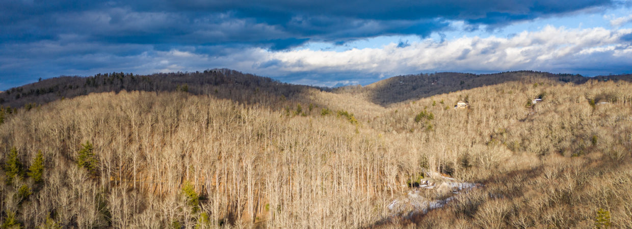
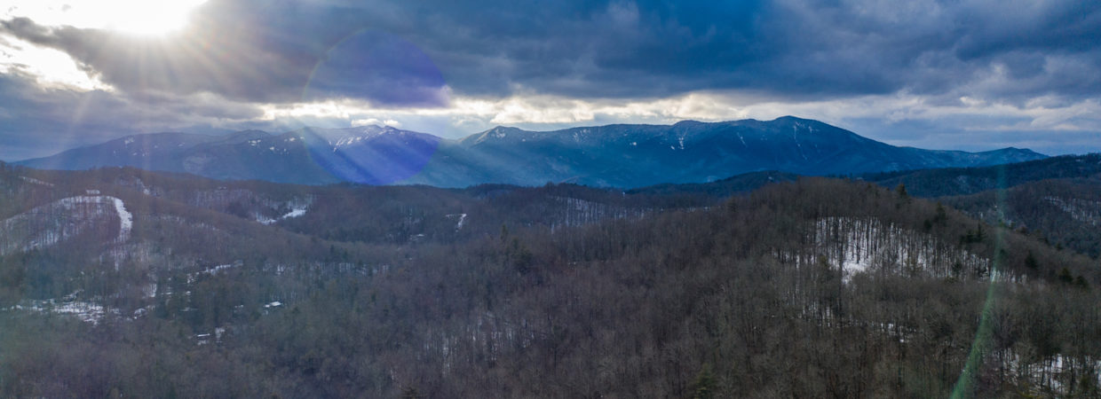
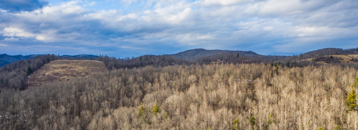
Welcome to your new homesite! This property at a glance:
Acreage: 5 acres
Assessed: $52,500
Priced: 35,000 $($17,500 or 34% below assessed value!)
Tucked away is this beautiful wooded 5 acre lot that is located in the desirable county of Mitchell. Take the private easement through natural wood cover to arrive at your future dream home site. Neighboring but private homes already established in the area make accessing utilities a breeze. This property is perfect for anyone seeking natural seclusion while still being within a short car ride to necessary amenities.
Come make this gorgeous 5 acre yours today, listed to sell at just $35,000. Call me at 858-261-7788 with any questions.
If you want to see this parcel in person, you can plug in the coordinates into your map Latitude: 35.8409858, Longitude: -82.1190998
NEARBY ATTRACTIONS/CITY
MITCHELL COUNTY, NC

Mitchell County is a county located in the U.S. state of North Carolina. As of the 2010 census, the population was 15,579.[2] Its county seat is Bakersville, population 454 (2010), elevation 2470 ft..[3]
The county is home to the “Mineral City of the World”, Spruce Pine and Roan Mountain which includes the world’s largest natural rhododendron garden, and the longest stretch of grassy bald in the Appalachian range. Throughout the year such festivals as North Carolina Mineral and Gem Festival and North Carolina Rhododendron Festival bring many people to the area. Mitchell County was one of the three dry counties in North Carolina, along with Graham and Yancey, but in March, 2009, after much controversy, the Town of Spruce Pine approved beer, wine, and ABC store sales. However, alcohol sales are still illegal in the areas of the county outside the town of Spruce Pine, except areas within 1.5 air miles of the Blue Ridge Parkway.
HISTORY
The county was formed in 1861 from parts of Burke County, Caldwell County, McDowell County, Watauga County, and Yancey County. It was named for Elisha Mitchell, professor of mathematics, chemistry, geology, and mineralogy at the University of North Carolina from 1818 until his death in 1857. Dr. Mitchell was the first scientist to argue that a nearby peak in the Black Mountains was the highest point east of the Mississippi River. He measured the mountain’s height and climbed and explored it. In 1857 he fell to his death on a waterfall on the side of the mountain. The mountain was subsequently named Mount Mitchell in his honor.
By 1899, Mitchell County had a sundown town policy of preventing African Americans from living or working in the county.[4]
The county took a direct hit from “The Storm of the Century”, also known as the “’93 Superstorm”, or “The (Great) Blizzard of 1993”. This storm event was similar in nature to a hurricane. The storm occurred between March 12–13, 1993, on the East Coast of North America. Parts of Cuba, Gulf Coast States, Eastern United States and Eastern Canada were greatly impacted.
The county suffered a tragic event on the evening of Friday, May 3, 2002 when a fire broke out at the Mitchell County jail in Bakersville, North Carolina. As a result of the fire eight men lost their lives.
GEOGRAPHY
According to the U.S. Census Bureau, the county has a total area of 222 square miles (570 km2), of which 221 square miles (570 km2) is land and 0.7 square miles (1.8 km2) (0.3%) is water.[5] It is the fourth-smallest county in North Carolina by land area and second-smallest by total area. The northwest sections of county border the State of Tennessee. Sections of both the Blue Ridge Parkway and Appalachian Trail are located in the county. Parts of the Pisgah National Forest and Roan Mountain State Park are located in the northern sections of the county. All over Mitchell and neighboring Avery County you will find several conservation lands within the Pisgah Forest. Little Yellow Mountain is a natural land conservation area and one day it will be turned over to the state.
ADJACENT COUNTIES
- Carter County, Tennessee – north-northeast
- Avery County – northeast
- McDowell County – south
- Yancey County – southwest
- Unicoi County, Tennessee – north-northwest
NATIONAL PROTECTED AREAS
- Blue Ridge Parkway (part)
- Pisgah National Forest (part)
MAJOR HIGHWAYS
DEMOGRAPHICS
| Historical population | |||
|---|---|---|---|
| Census | Pop. | %± | |
| 1870 | 4,705 | — | |
| 1880 | 9,435 | 100.5% | |
| 1890 | 12,807 | 35.7% | |
| 1900 | 15,221 | 18.8% | |
| 1910 | 17,245 | 13.3% | |
| 1920 | 11,278 | −34.6% | |
| 1930 | 13,962 | 23.8% | |
| 1940 | 15,980 | 14.5% | |
| 1950 | 15,143 | −5.2% | |
| 1960 | 13,906 | −8.2% | |
| 1970 | 13,447 | −3.3% | |
| 1980 | 14,428 | 7.3% | |
| 1990 | 14,433 | 0.0% | |
| 2000 | 15,687 | 8.7% | |
| 2010 | 15,579 | −0.7% | |
| 2018 (est.) | 15,000 | [6] | −3.7% |
| U.S. Decennial Census[7] 1790-1960[8] 1900-1990[9] 1990-2000[10] 2010-2013[2] |
ANCESTRY
As of 2015, the largest self-reported ancestry groups in Mitchell County were:[11]
| hideLargest ancestries (2015) | Percent |
|---|---|
| American | 17.3% |
| English | 14.7% |
| German | 12.2% |
| Irish | 11.9% |
| Scots-Irish | 9.8% |
| Scottish | 5.0% |
| French (except Basque) | 2.3% |
| Italian | 1.9% |
| Swedish | 1.6% |
| Dutch | 1.5% |
As of the census[12] of 2000, there were 15,687 people, 6,551 households, and 4,736 families residing in the county. The population density was 71 people per square mile (27/km2). There were 7,919 housing units at an average density of 36 per square mile (14/km2). The racial makeup of the county was 97.87% White, 0.22% Black or African American, 0.45% Native American, 0.20% Asian, 0.66% from other races, and 0.60% from two or more races. 1.98% of the population were Hispanic or Latino of any race.
There were 6,551 households, out of which 27.40% had children under the age of 18 living with them, 60.90% were married couples living together, 8.10% had a female householder with no husband present, and 27.70% were non-families. 25.20% of all households were made up of individuals, and 12.00% had someone living alone who was 65 years of age or older. The average household size was 2.37 and the average family size was 2.82.
In the county, the population was spread out, with 21.20% under the age of 18, 6.80% from 18 to 24, 26.40% from 25 to 44, 27.10% from 45 to 64, and 18.60% who were 65 years of age or older. The median age was 42 years. For every 100 females there were 95.60 males. For every 100 females age 18 and over, there were 92.30 males.
The median income for a household in the county was $30,508, and the median income for a family was $36,367. Males had a median income of $26,550 versus $20,905 for females. The per capita income for the county was $15,933. About 10.70% of families and 13.80% of the population were below the poverty line, including 17.20% of those under age 18 and 16.40% of those age 65 or over.
COMMUNITIES
Map of Mitchell County, North Carolina With Municipal and Township Labels
TOWNS
- Bakersville (county seat)
- Spruce Pine
TOWNSHIPS
- Bakersville
- Bradshaw
- Cane Creek
- Fork Mountain-Little Rock Creek
- Grassy Creek
- Harrell
- Poplar
- Red Hill
- Snow Creek
- Spruce Pine
UNINCORPORATED COMMUNITIES
- Bailey Settlement
- Bandana
- Buladean
- Clarrissa
- Estatoe
- Hawk
- Kona
- Ledger
- Little Switzerland
- Loafers Glory
- Penland
- Poplar
- Tipton Hill
- Red Hill
Owing to its high altitude and consequent strong Civil War-era Unionist sympathies, along with its rural nature, Mitchell is a powerfully Republican county. No Democratic presidential candidate has carried Mitchell County since Samuel J. Tilden in 1876. At this time Mitchell included Avery County, detached from it in 1911, and even more Republican. However, since Tilden’s win every Republican candidate has obtained at least sixty percent of the county’s vote, with the solitary exception of the 1912 election when the party was divided between the two candidacies of William Howard Taft and Theodore Roosevelt, the latter of whom carried the county.showPresidential elections results
LAW AND GOVERNMENT
Mitchell County is a member of the regional High Country Council of Governments.
EDUCATION
Mitchell High School is a comprehensive four-year high school (9-12) centrally located in the community of Ledger when built in 1978. The high school has achieved many educational and athletic accomplishments throughout its history.
Spruce Pine is home to three schools: Greenlee Primary (K-2), Deyton Elementary (3–5) and Harris Middle (6–8). Bakersville is home to two schools: Gouge Primary (K-4) and Bowman Middle (5–8).
Mayland Community College also calls Mitchell County home. Founded by an act of the North Carolina General Assembly in 1971, Mayland hosts some 35 curriculum programs and provides vocational and technical training, along with college transfer opportunities to residents of the region. Mayland was recently ranked 4th best community college in the nation according to 2010 Washington Monthly College Guide.
Penland School of Crafts is a world-renowned educational facility located in the Penland Community. It is designed to educate students who will apply workable knowledge in creation of books, paper, clay, drawing, glass, iron, metals, photography, printmaking and letterpress, textiles, and wood. Furthermore, Penland School of Crafts was established in the early 1920s, it is the largest and oldest professional crafts school in the United States.
ATHLETIC ACHIEVEMENTS
Mitchell High School is in the Western Highlands 1A conference, which is made up of 6 schools with 3 of the schools classified as 1A. They have the smallest enrollment of the schools in their conference. Three neighboring counties’ schools (Avery, Yancey (Mountain Heritage), and McDowell) are some of the common rivals of the Mountaineers.
- 1987–88 Football, 11–2 record, Final 8 in state
- 1987–88 Wrestling, State Champions
- 1996 Girls’ Basketball, State Champions
- 1999–2000 Boys’ Basketball, 23–5 record, Final 4 in state
- 2003 Girls’ Basketball, State Champions
- 2006–07 Wrestling, 45–3 record, Final 4 in state
- 2010 Football, lost one game before advancing to the State Championships
- 2011 Football, 2nd best championships record in school history
- 2011 Men’s Cross Country, finished 4th in 1A State Championship
- 2012 Men’s Cross Country, finished 5th in 1A State Championship
- 2013 Men’s Cross Country, finished 7th in 1A State Championship
- 2015 Football, 14–2 Record, 1AA State Runners-Up
MEDIA
The county is served by The Mitchell News-Journal, a weekly newspaper printed by Community Newspapers, Inc. and WTOE radio, at 1470 kHz on the AM dial to cover local news.
Virtual Tour