


Specification
Features
Location
Description
PAYMENT NOTE(S)
DESCRIPTION
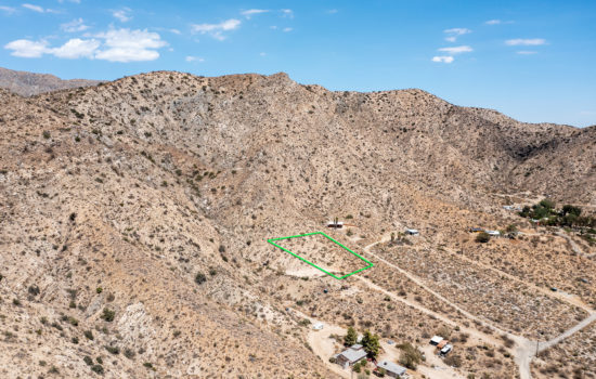
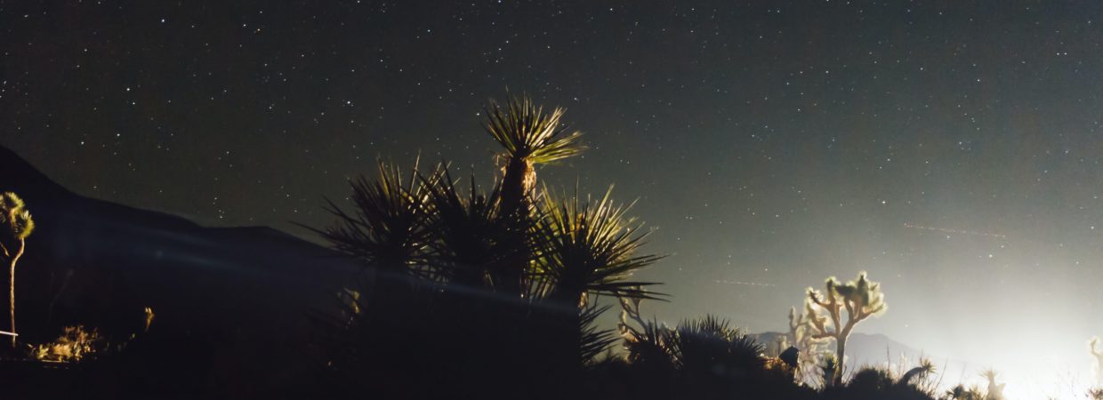
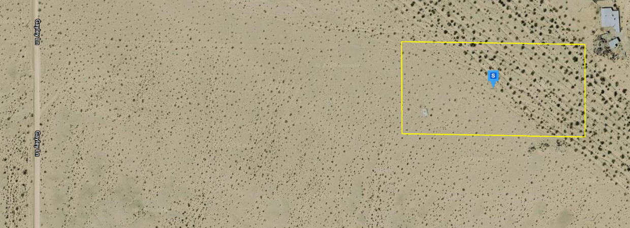
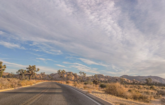
Stunning 5 acre parcel in Old Dale, California. Just 13.8 miles to the Joshua Tree National Park. This parcel is the perfect balance of wildness and convenience. This lot is just 10.8 miles from downtown Twentynine Palms.
Come camping, picnic, or perfect for a future building development. There are just a few neighbors in a 5 mile radius, this is the perfect place to find serenity and peace in the legendary California Desert.
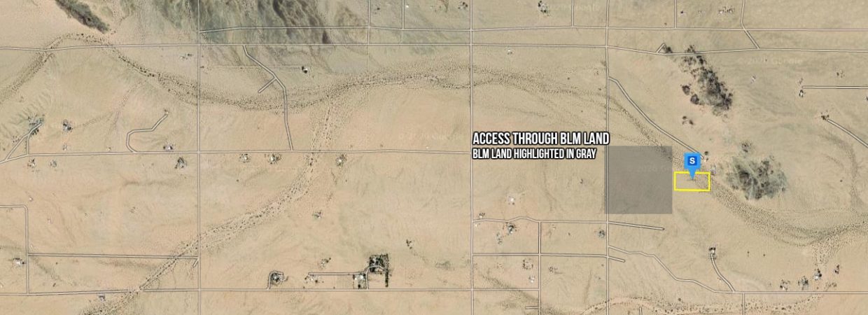
This lot is zoned residential, but has very few restrictions. Power is right off of Gayley Ln. Access off of Gayley Ln. through open BLM land.
This lot is the lowest priced 5 acre in the entire area, priced to sell at $12,700.
Give me a call at 831-392-7699 with any questions.
NEARBY ATTRACTIONS/CITY
TWENTY NINE PALMS
HISTORY
Twentynine Palms was named for the palm trees found there in 1852 by Col. Henry Washington while surveying the San Bernardino base line.[6] A post office was established in 1927.[7]
A road named Utah Trail honors the late 1800s pioneers on a trail originating in Utah (reportedly Saint George) that went to Twentynine Palms.[citation needed]
Nearby is a small Indian reservation belonging to the Twenty-Nine Palms Band of Mission Indians.
Joshua Tree National Park, which lies just to the south of Twentynine Palms, was designated a national monument in 1936, and became a national park in 1994. The nearby Marine Corps Air Ground Combat Center Twentynine Palms was founded in 1952.
DEMOGRAPHICS
| Historical population | |||
|---|---|---|---|
| Census | Pop. | %± | |
| 1970 | 5,667 | — | |
| 1980 | 7,465 | 31.7% | |
| 1990 | 11,821 | 58.4% | |
| 2000 | 14,764 | 24.9% | |
| 2010 | 25,048 | 69.7% | |
| 2019 (est.) | 26,073 | [5] | 4.1% |
| U.S. Decennial Census[8] |
Its population as of July 1, 2013 was estimated at 25,768.[9]
2010 CENSUS
At the 2010 census,[10] there were 25,048 people in 8,095 households, including 5,847 families, in the city. The population density was 423.5 people per square mile (163.5/km2). There were 9,431 housing units at an average density of 159.5 per square mile, of the occupied units 2,742 (33.9%) were owner-occupied and 5,353 (66.1%) were rented. The homeowner vacancy rate was 3.6%; the rental vacancy rate was 9.2%. 6,876 people (27.5% of the population) lived in owner-occupied housing units and 14,825 people (59.2%) lived in rental housing units. The racial makeup of the city was 71.6%, White (60.8% non-Hispanic),[9] 8.2% African American, 1.3% Native American, 3.9% Asian, 1.4% Pacific Islander, 6.7% from other races, and 6.9% from two or more races. Hispanic or Latino of any race were 20.8% of the population.
The census reported that 21,701 people (86.6% of the population) lived in households, and 3,347 (13.4%) lived in non-institutionalized group quarters.
Of the 8,095 households 43.3% had children under the age of 18 living in them, 54.5% were opposite-sex married couples living together, 12.9% had a female householder with no husband present, 4.9% had a male householder with no wife present. There were 5.0% unmarried opposite-sex partnerships, and 1.6% same-sex married couples or partnerships. 21.1% of households were one person and 5.6% were one person aged 65 or older. The average household size was 2.68 and the average family size was 3.10.
The age distribution was 25.6% under the age of 18, 30.0% aged 18 to 24, 25.5% aged 25 to 44, 13.1% aged 45 to 64, and 5.8% who were 65 or older. The median age was 23.5 years. For every 100 females, there were 129.0 males. For every 100 females age 18 and over, there were 139.9 males.
The median household income was $42,572. About 14.4% of the population were living below the poverty line.[9]
29 Palms has a good deal of racial diversity. The Hispanic population has increased 50% since the 2000 census. Also African-Americans, Filipinos, Samoans, and Native Americans form sizable percentages. And religiously, sizable communities of Mormons and Seventh-day Adventists.[citation needed]
2000 CENSUS
At the 2000 census there were 14,764 people in 5,653 households, including 3,855 families, in the city. The population density was 269.3 inhabitants per square mile (104.0/km2). There were 6,952 housing units at an average density of 126.8 per square mile (49.0/km2). The racial makeup of the city was 71.0% White, 9.4% African American, 1.5% Native American, 3.8% Asian, 10.2% Pacific Islander, 6.2% from other races, and 6.4% from two or more races. Hispanic or Latino of any race were 14.9%.[11]
Of the 5,653 households 39.1% had children under the age of 18 living with them, 49.8% were married couples living together, 13.7% had a female householder with no husband present, and 31.8% were non-families. 25.1% of households were one person and 7.4% were one person aged 65 or older. The average household size was 2.6 and the average family size was 3.1.
The age distribution was 31.2% under the age of 18, 15.2% from 18 to 24, 28.4% from 25 to 44, 16.7% from 45 to 64, and 8.6% 65 or older. The median age was 27 years. For every 100 females, there were 101.8 males. For every 100 females age 18 and over, there were 98.7 males.
The median household income was $31,178 and the median family income was $32,251. Males had a median income of $25,081 versus $25,141 for females. The per capita income for the city was $14,613. About 13.6% of families and 16.8% of the population were below the poverty line, including 25.3% of those under age 18 and 10.0% of those age 65 or over.
GEOGRAPHY
The city is located in the Mojave Desert in Southern California. It lies on the northern side of the Joshua Tree National Park and includes one of the entrances to the park, at the Oasis of Mara.
According to the United States Census Bureau, the city has a total area of 59.1 square miles (153 km2), all land.[12] The city is at an elevation of 1,988 feet (606 m).[1] The Marine Corps Air Ground Combat Center Twentynine Palms is located there.
CLIMATE
Due in large part to its elevation of more than 1,900 ft (580 m) above sea level, Twentynine Palms has a slightly cooler climate, especially during winter, than Palm Springs, but with essentially the same subtropical desert characteristics. On average, temperatures reach 100 °F (38 °C) on 90 days, 90 °F (32 °C) on 155 days, and the freezing mark on 24 nights annually. Extremes range from 10 °F (−12 °C) on December 23, 1990, to 118 °F (48 °C) on July 11, 1961. Winters are moderately cool, with highs in the 60 °F (16 °C) and the lows in the 40 °F (4 °C). Summers are hot, with temperatures above 100 °F (38 °C). The rainiest month is August with 0.8 in (20 mm) inches of rain, mostly from monsoon thunderstorms.
Virtual Tour
2.5 Acres Zoned Airport Park in Adelanto, CA
Stunning 20 Acre Parcel In Desert Heights W/ Owner Financing – Put $7,500 Down and finance the rest with 0% Interest!
Just $775 Down for This 2 Acre Lot In Sunfair Heights in San Bernardino, CA!